Jay Cooke State Park is a Minnesota state park near Carlton, covering 8,938 acres. Hours: Daily from 8 a.m. until 10 p.m. It offers camping or lodging. Entry needs a state park vehicle permit, $7 for a day, as the DNR fees page said on October 19, 2026.
- 8,938acres
- Carltonmailing town
- Yesovernight stays
- $7day vehicle permit
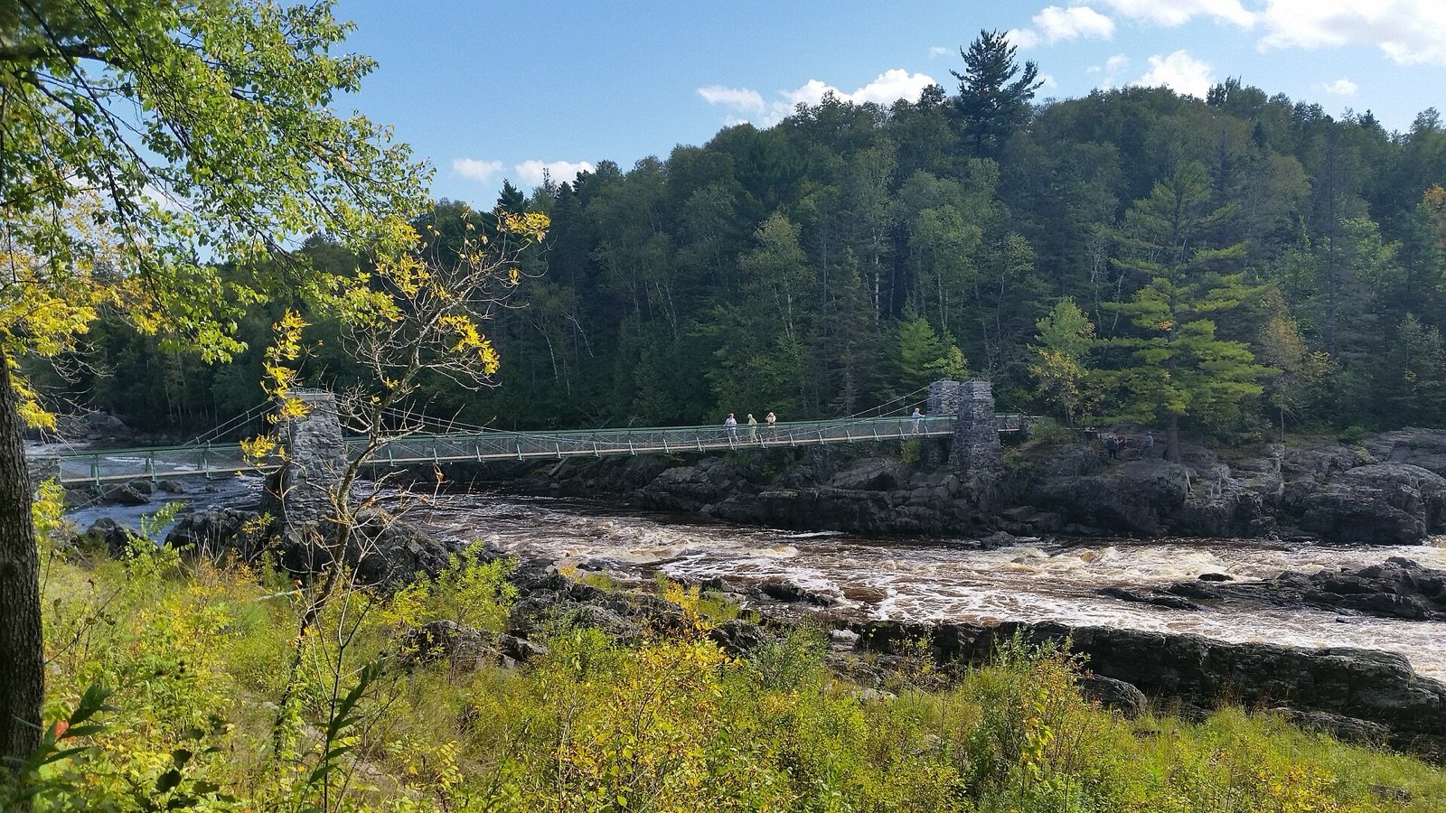
- Swinging bridge across the river
- Camping
- Hiking
- Skiing and snowshoeing
- Historic cemetery and Thomson Dam gorge
- 173 species of birds nest and feed in the park
Plan It In Three Lines
- Hours: Daily from 8 a.m. until 10 p.m.
- Cost: a $7 one-day vehicle permit or a $35 year-round permit, per the DNR fees page of October 19, 2026; confirm before you go.
- Pets: leashed (six feet or shorter) outside buildings, lodging and beaches, per the DNR rules page; park-specific limits are listed below.
About The Park
The DNR describes it: Park trails connect to the Willard Munger State Trail on the north side of the park. Check out the wildflowers in the spring, and the vivid colors in the fall. Walk on the swinging suspension bridge high above the Saint Louis River. Visit the historic cemetery and the gorge at Thomson Dam.
Wildlife. The promise of food and protection make Jay Cooke State Park an important wintering area for white-tailed deer. Black bear, timber wolf, and coyote are among the largest of 46 animal species in the park.
History. Jay Cooke State Park was established in 1915 when the St. Louis River Power Company donated 2,350 acres of land. In 1945, the state purchased additional land.
Geology. The geological makeup of Jay Cooke State Park is one of slate, greywacke and red clay. The St. Louis River, Lake Superior's largest U. S. tributary, has exposed the bedrock in many places.
Visit Facts
- Address780 Highway 210 Carlton, MN 55718
- Phone218-673-7000
- Park hoursDaily from 8 a.m. until 10 p.m.
- Park office hoursThe office and River Inn buildings are typically open 10 a.m. to 4 p.m. There may be times when they are not open during those hours due to staff limitations. If you are arriving after hours for camping, you will need to check in using the reservation website or call center.
- Emailjaycooke.statepark@state.mn.us
- Park GPS point46.66159, -92.39908 (DNR printed coordinates)
- Official pageDNR page for Jay Cooke State Park
Trails
| Season | Trail type | Length | Notes |
|---|---|---|---|
| Summer | Accessible | 0.5 miles | — |
| Summer | Hiking | 50 miles | Great scenic views! Trails take you through wooded areas and along the river. |
| Summer | Paved Bike | Eight miles | The trail connects Carlton with the park. |
| Summer | Unpaved Bike | 13 miles | — |
| Summer | Horse | Six miles | — |
| Winter | Groomed Cross-Country Skiing Classic | 32 miles | Trails range from easy to difficult, with the easiest trails located the closest to the visitor center. The park grooms up to 20 miles of ski trails, plus an additional 12 miles as conditions and time allow. A Great Minnesota Ski Pass is required on groomed ski trails for skiers age 16 and up. |
| Winter | Snowmobile | Less than one mile | The park's trail is short, but connects with the Willard Munger State Trail system. |
| Winter | Snowshoe | Nine miles | Trails range from easy to difficult, and are packed and marked for snowshoeing and hiking. Snowshoers may also explore any off-trail areas of the park, but must keep off groomed ski trails. Snowshoe rentals are available at the River Inn visitor center. |
Camping And Lodging
| Type | Detail | Notes |
|---|---|---|
| Drive-in Sites | 79 sites, mostly wooded | 12 sites stay open for winter camping, five with electricity. |
| Pull-Through Sites | One site | — |
| Electric Sites | 21 sites | Mostly 20 and 30 amps, some 50 amp. |
| RV Length Limit | Varies between sites – up to 60 feet | Distance is measured from front of tow vehicle to rear of vehicle being towed. |
| Accessible Sites | Three sites, near drinking water | The campground has three accessible drive-in sites. Two sites are electric, one is non-electric. |
| Backpack Sites | Four sites | Each has a picnic table, fire ring, latrine and bear box. Campers must haul water or treat water on site. Gathering of dead and downed firewood near the backpack sites is allowed. Distances from park office/swinging bridge area parking lot to site: Silver Creek – 2 miles Ash Ridge – 2.7 miles High Landing – 2.4 miles Lost Lake: 3.3 miles |
| Walk-in Sites | Four sites, located 50-150 feet from parking | — |
| Group Camp | Two sites, each accommodates up to 25 people | Tents only! Sites share a water spigot and vault toilets. Remote, wooded camp with walk-in sites approximately 150' from parking area. Parking is limited. Carts are provided to carry in camping gear. |
| Accessible Lodging | 2 accessible camper cabins | The Agate and Basalt camper cabins are accessible. |
| Camper Cabins | Year-round | Five camper cabins with screened porches, heat and electric, available year-round. No pets. Slate, Gabbro and Shale each sleep six. Agate and Basalt are accessible and each sleep five. More information on camper cabins. |
Reservations go through the DNR system; start from the park page.
On The Water
The DNR lists no water recreation here.
Other Recreation
| Type | Detail | Notes |
|---|---|---|
| Picnic Area | Two picnic areas | One is outside the visitor center, and the other is at Oldenburg Point, one mile past the park office on Highway 210. |
| Picnic Shelter | Two shelters | Oldenburg Point Shelter Open shelter with a fireplace and electricity, accommodates up to 75 people. Two- to five-minute walk from the St. Louis River overlook. Call the park to reserve. Not available for rent during fall color weekends, due to high day use and parking constraints. Rental does not include exclusive use of any overlooks or surrounding day use areas. |
| Other | — | Hammocks Hammocks may only be hung over mowed areas, such as in campsites and picnic areas. Trees used must be at least 12 inches in diameter at the point a hammock is attached. Use straps at least one inch wide to attach your hammock, and hang only one hammock per tree. |
| Warming House | At the River Inn Interpretive Center | — |
Amenities
| Type | Detail | Notes |
|---|---|---|
| Ranger Station | Open year-round, in the visitor center | Stop here for vehicle permits, camping registration, and information about the park. |
| Visitor Center | — | Restrooms, vending machines, interpretive displays, and Nature Store. |
| Interpretive Exhibit | Many throughout the park | Learn about park history, wildlife and geology. |
| Naturalist Programs | — | Programs are generally available in the summer, with occasional programs offered throughout the year. Call the park to schedule a program for your school or group. |
| Historic Site | Throughout the park | Pioneer Cemetery is located along Highway 210, about one mile west of the park office. The swinging bridge spans the St. Louis River, one block from the park office. Five miles east of the park office, the Grand Portage Trail was used by voyageurs to maneuver around the rocks and rapids of the St. Louis River. |
| Gift Shop | In the visitor center, open year-round | — |
| Rentals | — | Fishing kits (rod, reel, stocked tackle box), birding kits, sensory kits (headphones, fidget toys, calming toys), and kids discovery kits (activities and stories designed for age 5-12) are available to check out for free at the River Inn visitor center. Snowshoes rentals are available from the ranger station in winter. |
| Firewood | Available year-round at the visitor center | — |
| Ice Sales | Seasonal, at the visitor center | — |
Pets And Permits
Statewide, the DNR rules page says pets are welcome in state parks on a leash six feet or shorter, attended at all times; only service animals are allowed in buildings, lodging, tours and beach areas. A vehicle permit costs $7 a day or $35 a year (DNR fees page, read October 19, 2026). See the parks passport page for the full price list.
Park-specific: No pets.
Directions
From the town of Carlton go three miles east on State Highway 210 to use the west park entrance.
Map © OpenStreetMap contributors. Directions.
Nearby Places
- Moose Lake State ParkState Park, about 22 miles away in a straight line
- Banning State ParkState Park, about 40 miles away in a straight line
- Savanna Portage State ParkState Park, about 41 miles away in a straight line
- St. Croix State ParkState Park, about 46 miles away in a straight line
- Gooseberry Falls State ParkState Park, about 55 miles away in a straight line
What We Could Not Verify
- Current alerts, closures, trail and campground conditions: they change daily. Read the DNR park page before you go.
- County: the DNR page does not state it, so we do not print one.
- Fees for lodging and group sites, and day-by-day availability: set by the DNR reservation system.
- Permit prices were read on October 19, 2026 and the DNR page shows no effective date.
- The map point is the park’s printed coordinate, not a verified entrance.
Related Pages
More In Duluth & North Shore
- Canal Park and the Lakewalk, Duluth
- Grand Portage National Monument
- Lake Superior Maritime Visitor Center
- Split Rock Lighthouse Historic Site
- Superior Hiking Trail
- Cascade River State Park
- George H. Crosby Manitou State Park
- Gooseberry Falls State Park
- Grand Portage State Park
- Judge C.R. Magney State Park
- Events in Duluth & North Shore
Frequently Asked Questions
Where is Jay Cooke State Park?
It is near Carlton, Minnesota. The DNR address is 780 Highway 210 Carlton, MN 55718.
How much does it cost to visit Jay Cooke State Park?
A one-day vehicle permit is $7 and a year-round permit is $35 on the DNR fees page we read on October 19, 2026. Check the fees page before you go.
Are dogs allowed at Jay Cooke State Park?
Pets are welcome on a leash six feet or shorter outside buildings, lodging, tours and beach areas, per the DNR rules page. This park’s page adds limits listed in Pets And Permits above.
Sources
- Jay Cooke State Park (DNR Recreation Compass data) (read November 1, 2026).
- Minnesota state park fees (DNR) (read November 1, 2026).
- Minnesota state park rules (DNR) (read November 1, 2026).
- Minnesota State Parks Passport, all places, park fees and rules.